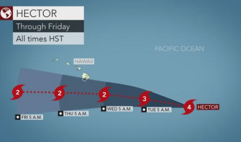
The image above is the Category 4 Hurricane that will soon be affecting Hawaii’s Big Island.
Photo Credit: Accuweather.com
North – The Northeastern states will have temperatures in the upper 80’s and 90’s in the beginning of the week. A cold front traveling from Midwestern states to the Northeast will also likely bring thunderstorms and rain on Tuesday from North Carolina to Maine.
South – From Florida to Alabama along the panhandle, there were more than 125 rescues from dangerous rip currents. Luckily no fatalities resulted but the rip currents can reach speeds higher than 6mph which pull swimmers away quickly. Storms and rain will increase this week in many of the Southern states from Texas to Florida and from Arkansas to Virginia.
Midwest – Midwestern states will start off the week with above average temperatures from the Great Lakes to the Northeast. A cold front will move from the plains to the upper Midwest today causing a chance of thunderstorms into Tuesday.
West – Category 4 Hurricane Hector is likely to hit Hawaii on Wednesday, while losing some intensity. It will brush Big Island and cause high rip currents and flooding. The rip currents will affect beaches on the East side of the island. Expect heavy rain and Tropical storm force winds of over 39mph. Heat once again returns to the West from Idaho to Washington, where you can expect temperatures in the low to high 90’s. Expect excessive heat in Arizona, California and Nevada which pose a fire danger.


Comments by Direct Connect Auto Transport